


Heysham Heritage Trail - Self Guided Walking Trail
Start from the main car park in the village. Walk across the road to reach Main Street. Look to the right and you will notice the village institute built in 1897 where the villagers still get together for meetings and social events.
Carry on along Main Street and look at the different date stones on the houses - the earliest is from 1633. After 50 metres, you will reach Heysham Heritage Centre on the right. The Heritage Centre was formerly the barn for the adjoining 17th century farmhouse. Go in to learn all about the fascinating history of this small Lancashire village (seasonal opening and selected days; please see website for details).
Walk along Main Street until you reach The Royal Hotel on the left. There has been a building here since the early 1500’s when it was used as the village corn store. Granny Hutchinson lived in the cottage next door to the pub in the early 1900s, which is now called Nettle Cottage. She was one of many local people who made and sold Heysham’s famous Nettle Beer - a non-alcoholic drink with a distinctive flavour!
Keep going along Main Street past the cottages on the right with the date stone BRI 1721 to reach St Patrick’s Well, set into the wall on the left. This was one of several wells that supplied the old village with water. The water from St Patrick’s Well, also known as Church Well was notoriously ‘brackish’!
Just beyond the Well, turn left onto the drive which leads towards the Parish Church and the headland. On the left is St Peter’s Church Hall, formerly the stables, which serves delicious refreshments during the summer months. Nearby stood the 19th century Rectory which was demolished in the 1950s and replaced by the present building located behind the Church Hall.
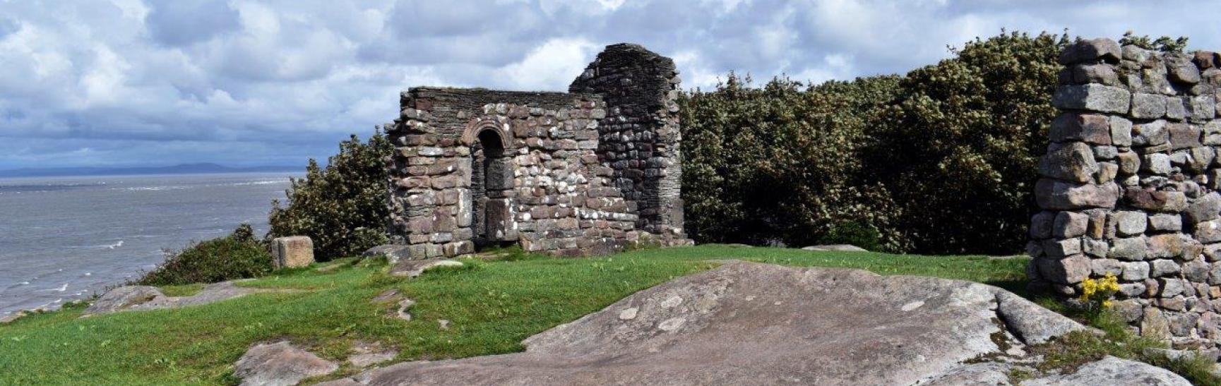
Head straight up the pathway to the headland and St Patrick’s Chapel. Follow the pathway through an archway overlooking the sea. Here you will see the ancient ruins of St Patrick’s Chapel and the rock-hewn Viking graves, thought to date back to the 8th century. From here there is the option to follow the coastal path to Half Moon Bay (10min) to view the impressive bronze and steel sculpture ‘The Ship’, designed by artist Anna Gillespie and commissioned by Morecambe Bay Partnership as part of the Headlands to Headspace project. Return the same way back to the Chapel.
Head back down the pathway then turn left through the gate into St Peter’s churchyard. Take the left pathway and you will see the base of a late 8th century Anglian stone cross. A little further along on the right is a stone pillar, used as the base for a sundial and dated 1696, also thought to have been the shaft of an Anglican cross re-shaped by 17th century Puritans.
Continue along the path to the porch of St Peter’s Church. The church contains many important artefacts including the world-famous 'Hog Back Stone' (Viking grave stone). St Peter’s is one of the oldest churches in Lancashire. It was first recorded in 1080 but it is believed that there was a church here about 300 years earlier. St Peter’s has been progressively altered over the centuries and a booklet about its history is available inside the church. Open Mon-Sat in summer, Wed and Sat in winter.
Walk round to the left of the porch, following the west wall. The blocked arched doorway in the wall dates from the 10th century. Did you notice a similar stone doorway in the south west corner of the graveyard? This was removed from the church when a new north aisle was added in 1864 by the Rev. John Royds. Have you read the plaque on its wall?
Return to the path and follow it around to the north side of the church. This rear porch which projects from the north aisle incorporates several 17th century and 18th century date stones from houses in the village.
Can you find the grave which is close by of the unfortunate Sarah Hannah Jones, one of the wives of James Jones, which bears the inscription “Poet, Philosopher, Failure”?
Turn right along the path, heading back towards the church gate and turn left through the opening in the wall to what looks like a secret garden known as the Glebe Garden. The word ‘glebe’ means ‘land belonging to the church’.
This tranquil garden has been restored by local volunteers. Among the many plants in the garden you can find the rosa gallica officinalis – the Red Rose of Lancaster.
Return to the path and leave the churchyard by the main gate. Turn left into Main Street down the hill to the Old Rectory, also known as Greese Cottage. This building was used by the Rector until a new Rectory was built in the 19th century near the present Church Hall. The name Greese is thought to be derived from the Latin word for steps.
Carry on past the Old Rectory and down to the shore. Until the early 1900’s people supplemented their income from farming by collecting mussels from the rock outcrops in the Bay. These are known locally by the Norse word ‘skears’ and can be clearly seen at low tide. Horses and carts came onto the shore at Lade End to take the mussels to Morecambe, from where they were transported by rail to the industrial towns of Lancashire and Yorkshire.
Walk back up Lade End to Main Street, turn left on to Bailey Lane, walk about 20 metres and turn left onto the footpath marked Whinnysty Lane. The coastal path links Heysham with its near neighbour Morecambe. On a clear day you can see the Lakeland fells and mountains across Morecambe Bay.
Take the path which rises gently uphill. After about 100 metres, turn right along the footpath which runs inland, where the path emerges at the road junction, turn right along Knowlys Road and walk 50 metres to the gate in the wall on the right. Immediately opposite the gate is a house named ‘Turner’s View’. In 1816 the artist Joseph Turner stopped briefly somewhere near this spot. He made 4 pencil sketches one of which was later used for his famous water colour, “Heysham and Cumberland Mountains”.
Continue downhill along Knowlys Road until you reach the cross roads with Bailey Lane and St Mary’s Road. A village water pump stood in the middle of the junction until the 1930s when it was removed after it was damaged by a motor car, and re-sited opposite. Have you found it?
Walk straight across the junction to Bailey Lane, and follow the road around to the left. The building on the left is Carr Garth, which was probably built in the 17th century. It has been used as a private boarding school, a nursing home for officers in the First World War, and as a holiday home for clergy and their families.
After a very short distance, turn right into the cul-de-sac onto the signposted footpath known locally as The Stye. Walk up the steps and back to Main Street. The name ‘Stye’ comes from the Old English word for a ‘narrow or steep path’. Turn left onto Main Street to return to the car park.
